|
The Olecko region is one of the most beautiful parts of Masuria ( Mazury/ the
Land of Great Mazurian
 Lakes). The region boasts its microclimate, dozens of
lakes and vast areas of forests. Its touristic value makes the region an
attractive site for investors. Local authorities take particular care to
preserve the region’s natural beauty,clean air, unpolluted waters and soils.
Local governments are obliged to continuously monitor and invest in the
environmental protection. Lakes). The region boasts its microclimate, dozens of
lakes and vast areas of forests. Its touristic value makes the region an
attractive site for investors. Local authorities take particular care to
preserve the region’s natural beauty,clean air, unpolluted waters and soils.
Local governments are obliged to continuously monitor and invest in the
environmental protection.
The Olecko region stretches to the north- east corner of the warmińsko-
mazurskie voivodship. It
 borders with the Giżycko region in the west, the Ełk
region in the south, the district of Gołdap in the north, and the Suwałki region
in the east. The Olecko region is divided into smaller administrative units (they
are also the names of towns within the district): Kowale Oleckie, Olecko,
Świętajno and Wieliczki. borders with the Giżycko region in the west, the Ełk
region in the south, the district of Gołdap in the north, and the Suwałki region
in the east. The Olecko region is divided into smaller administrative units (they
are also the names of towns within the district): Kowale Oleckie, Olecko,
Świętajno and Wieliczki.
The region covers 874 sq km.
Its population is 21 413 (16 169 in Olecko, 5 371 in Kowale Oleckie, 3 420 in
Wieliczki, 4 011 in Świętajno)
The History of Olecko
 In
the prehistoric times, the Baltic tribes, such as Jaćwingowie, lived in the area.
However, the only things that still remind us of the early tribes are the
geographical names used in the region. Teutonic Knights came here in the 15th
and the 16th centuries. After the Teutonic Order had been secularized, a small
wooden hunting castle was built on the narrow peninsula between the Oleckie
Wielkie lake and River Lega. In 1560, Albrecht Hohenzollern (a Prussian prince)
and the Polish king Zygmunt August started a town here called Marggrabowa. They
built an Evangelical church and a town hall in the centre of a 5,5- ha- big
square, which people called Oletzko. The development of that settlement was
rather slow due to numerous wars fought in the region in the 17th and 18th
centuries and the fact that Oletzko was situated away from the major trade
routes. It was not until the end of the 18th century that the town grew. (At
that time it belonged to the country of Prussia.) In the second half of the 19th
and at the beginning of the 20th century light industries were started in
Oletzko, but again, the WWI delayed further development until the years 1918-
1939. In
the prehistoric times, the Baltic tribes, such as Jaćwingowie, lived in the area.
However, the only things that still remind us of the early tribes are the
geographical names used in the region. Teutonic Knights came here in the 15th
and the 16th centuries. After the Teutonic Order had been secularized, a small
wooden hunting castle was built on the narrow peninsula between the Oleckie
Wielkie lake and River Lega. In 1560, Albrecht Hohenzollern (a Prussian prince)
and the Polish king Zygmunt August started a town here called Marggrabowa. They
built an Evangelical church and a town hall in the centre of a 5,5- ha- big
square, which people called Oletzko. The development of that settlement was
rather slow due to numerous wars fought in the region in the 17th and 18th
centuries and the fact that Oletzko was situated away from the major trade
routes. It was not until the end of the 18th century that the town grew. (At
that time it belonged to the country of Prussia.) In the second half of the 19th
and at the beginning of the 20th century light industries were started in
Oletzko, but again, the WWI delayed further development until the years 1918-
1939.
In 1920, people living in this territory decided by plebiscite that Oletzko
remained a German town, and between the years 1928- 1945 it was called Treubrg (meaning
the faithful city). Between the two world wars, Olecko was an important sports
resort and a recreation centre. During the WWII, though, the city was largely
devastated (about 60% was ruined), the narrow gauge railroad was damaged, and
the industry liquidated.
 Olecko has been a Polish city since 1945. Between 1946- 1975 it was the seat of
the local government and due to the administrative reform it became a separate
administrative district. Olecko has had the status of a city since 1999. Olecko has been a Polish city since 1945. Between 1946- 1975 it was the seat of
the local government and due to the administrative reform it became a separate
administrative district. Olecko has had the status of a city since 1999.
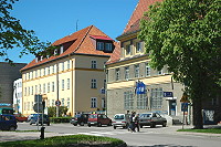
The square in the centre of the town with the adjacent (perpendicular) streets
is how Olecko used to look at the beginning. Today, the old brick building by
the lake (a former seat of the local council) houses a state vocational school
and the private Mazurian University. Nearby, there stands a 19th-century church,
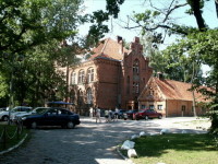
built in the late Gothic style. The trees on other shore hide a wooden house,
built in a typically Mazurian style called “ Chata Mazurska” (a Mazurian House).
The town itself includes many old apartment buildings (19th,early 20th century),
a water mill which dates back to 1895, and near the centre, on the hill-top
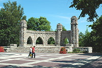
there stands an old water tower. The park in Gołdapska street houses a stone
monument with stone swords on the pillars. It commemorates those who died and
suffered during the WWI. Not far from that memorial there is a bridge which used
to go over the narrow gauge railroad. Today, the park which used to be called
the Hindenburg’ Park before WWII, houses a sports centre with a stadium, tennis
courts, and a horse-racing court.
Geography of the region
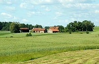 The
glacier which retreated and returned here several times left and outstanding
post-glacial landscape and over 15 lakes. Many streams cut across the land and
link some of the fifteen lakes. The Borecka Forest is a place where you will
find unique examples of plants and animals. Numerous lakes, streams and rivers
and rare mäcroclimate make the region an attractive tourist destination. The
glacier which retreated and returned here several times left and outstanding
post-glacial landscape and over 15 lakes. Many streams cut across the land and
link some of the fifteen lakes. The Borecka Forest is a place where you will
find unique examples of plants and animals. Numerous lakes, streams and rivers
and rare mäcroclimate make the region an attractive tourist destination.
The region is situated in the north-east corner of Mazury, on the route that
connects the Great Lakes Valley with the Suwalki- Augustów Lake District, and
lies within the borders of three mezoregions, i.e.: the Ełk Lake District, the
West Suwałki Lake district, and the Szeski Hump, in the Ełk and Lega rivers
basins. In the north-west corner, the Olecko region is encompassed by the
Borecka Forest. Steep hills ( the height above the sea level varies from 121m in
the south -220 m in the north-east) and ridges, characteristic of the whole
Mazurian landscape, were curved during three major glacial periods.
 The Oleckie Wielkie Lake: The Oleckie Wielkie Lake:
Situated on the run of River Lega which falls into River Ełk and then River
Biebrza
Height of the surface- 158 metres above the sea level
Length: 4,600 metres
Maximum width: 1,150 metres
Maximum depth: 45,2 metres
Area: 227 ha
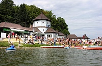
I TOURISM
One of the least polluted regions of Poland
Unique in Poland for its scenic views
Vast areas of forests, rivers and lakes
Highly diversified fauna
Good tourism infrastructure

II SPORTS FACILITIES
A paradise for hiking, walking, cycling and hunting enthusiasts
Great conditions for yachting, fishing and mushroom picking
Camping sites
Network of water-sports facilities, equipment rentals
Sport centres with tennis courts, football pitches, stadiums, etc.
Agro tourism with good quality accommodation and traditional Polish cuisine
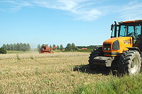
III ECONOMY
peatlands, clay ground, bilberries, and springs of mineral waters
good infrastructure for wood industry
Mazurian University in Olecko
Network of hotels, restaurants and bars
A boatyard for sailing yachts and motor boats
Production of the sewage treatment plants
|
 +87 520
21 47
+87 520
21 47